Coverage analysis
With the 3MAP tools we can display different user data necessary to carry out various analyses and data control.
The NUSZ coverage analysis is a GIS application intended for data operators to calculate the charge for the use of building land (NUSZ). It enables graphic viewing of NUSZ areas and other data from the NUSZ database with the purpose of comparing, editing and updating NUSZ data, viewing NUSZ payers and properties for which the charge is being calculated or not.
For each selected property users are displayed comparative data as an accessory to select, filter, coordinate data and maintain the NUSZ payers’ database.
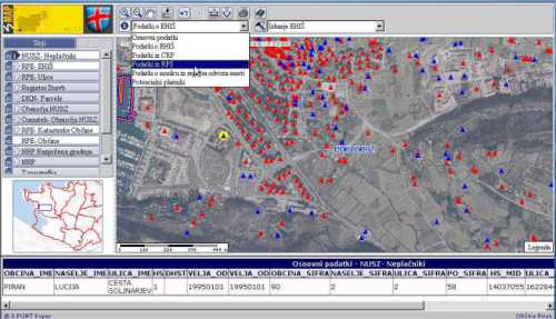
An example of data filtering for properties for which the charge for the use of building land (NUSZ) is not calculated (i.e. the description below the figure).
Services for generating layers are initiated on a determined time period and according to data in the business database they prepare geocoded layers, such as layers of issued location information, layers of issued land use permits, layers of building permits, etc.